Climate change poses unprecedented challenges to humanity, threatening ecosystems, economies, and communities worldwide. The integration of artificial intelligence with satellite technology is transforming how we predict, prepare for, and respond to environmental risks, creating powerful tools for a more resilient future.
As global temperatures rise and extreme weather events become more frequent, traditional methods of climate monitoring and prediction are no longer sufficient. The convergence of AI algorithms with vast amounts of satellite data offers unprecedented opportunities to understand complex climate patterns, identify vulnerabilities, and implement targeted interventions before disasters strike.
🌍 The Power of Satellite Eyes: Monitoring Earth from Above
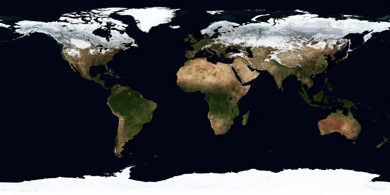
Satellite technology has revolutionized our ability to observe Earth’s systems in real-time. Modern Earth observation satellites capture terabytes of data daily, tracking everything from sea surface temperatures to deforestation rates, ice sheet movements to urban heat islands. This constant stream of information provides scientists and policymakers with a comprehensive view of our planet’s changing climate.
Organizations like NASA, ESA, and private companies have deployed sophisticated satellite constellations that monitor multiple climate indicators simultaneously. These instruments measure atmospheric composition, track greenhouse gas emissions, observe vegetation health, and detect subtle changes in land use patterns that might escape ground-based observation.
The real breakthrough comes when this massive data collection meets artificial intelligence. Raw satellite imagery alone can overwhelm human analysts, but AI systems can process millions of images, identify patterns invisible to the human eye, and generate actionable insights at unprecedented speeds.
🤖 Artificial Intelligence: The Climate Action Game-Changer
Machine learning algorithms excel at finding complex patterns in vast datasets, making them ideal partners for satellite-based climate monitoring. Deep learning models can analyze multispectral imagery to detect early warning signs of droughts, predict flood zones with remarkable accuracy, and identify areas most vulnerable to wildfires before they ignite.
Neural networks trained on historical climate data can recognize subtle indicators that precede major weather events. These AI systems learn from decades of observations, improving their predictions with each new data point. The result is a predictive capability that far surpasses traditional statistical models.
Computer vision algorithms process satellite imagery to track deforestation in near real-time, monitor glacier retreat, assess crop health across vast agricultural regions, and measure urban expansion. This automation allows environmental agencies to respond quickly to emerging threats rather than discovering problems weeks or months after they occur.
Natural Language Processing for Climate Intelligence
Beyond image analysis, AI-powered natural language processing helps researchers synthesize findings from thousands of climate studies, identify emerging trends in scientific literature, and communicate complex climate risks to diverse audiences. This capability accelerates knowledge transfer and helps bridge the gap between scientific research and policy implementation.
📊 Predicting Climate Risks with Unprecedented Precision
The combination of AI and satellite data enables risk prediction across multiple timescales and geographic scales. Short-term predictions help communities prepare for imminent storms or heatwaves, while long-term forecasts guide infrastructure planning and climate adaptation strategies.
Flood prediction systems now integrate satellite observations of rainfall, soil moisture, topography, and river levels with AI models that simulate water flow across landscapes. These systems can forecast flooding days in advance, providing crucial time for evacuations and emergency preparations.
Drought monitoring has become significantly more sophisticated through AI analysis of satellite data. Machine learning models assess vegetation indices, soil moisture content, precipitation patterns, and temperature anomalies to identify drought conditions before they become severe. Early warning systems allow agricultural communities to adjust planting schedules, implement water conservation measures, and access support programs proactively.
Wildfire Risk Assessment
AI-powered wildfire prediction represents one of the most dramatic success stories in climate risk management. Satellite data on vegetation dryness, temperature, wind patterns, and historical fire behavior feeds into machine learning models that identify high-risk areas with remarkable accuracy. These systems can predict fire spread patterns, helping firefighters allocate resources effectively and communities plan evacuations strategically.
🏙️ Building Climate-Resilient Cities with Smart Technology
Urban areas face unique climate challenges, from extreme heat to flooding, air pollution to infrastructure stress. AI analysis of satellite data helps city planners identify urban heat islands, optimize green space placement, improve drainage systems, and design climate-adapted infrastructure.
High-resolution satellite imagery combined with machine learning reveals which neighborhoods face the greatest climate risks. This information enables targeted interventions such as tree planting programs, reflective surface installations, and improved cooling infrastructure in vulnerable communities.
Transportation networks, energy systems, and water infrastructure can all be optimized using AI insights derived from satellite observations. Predictive models help utilities anticipate demand spikes during extreme weather, plan maintenance schedules around climate risks, and design resilient systems capable of withstanding future conditions.
🌾 Agricultural Resilience Through Precision Climate Intelligence
Agriculture remains one of the sectors most vulnerable to climate change. AI-powered satellite monitoring provides farmers with precision information about soil moisture, crop health, pest risks, and optimal planting windows. This technology democratizes access to advanced agricultural intelligence, benefiting smallholder farmers in developing regions as much as large commercial operations.
Yield prediction models trained on satellite data help agricultural markets anticipate supply fluctuations, allowing governments and aid organizations to prepare for food security challenges before crises emerge. These systems track crop conditions across entire regions, identifying areas where drought, flooding, or disease threatens harvests.
Precision agriculture applications use satellite data to optimize irrigation, reduce fertilizer use, and minimize environmental impacts while maintaining productivity. By identifying specific field areas requiring attention, farmers can apply resources more efficiently, reducing costs and environmental footprints simultaneously.
🌊 Ocean and Coastal Protection Through Advanced Monitoring
Coastal communities face escalating risks from sea-level rise, storm surges, and ocean acidification. Satellite observations of sea surface temperatures, ocean currents, and coastal erosion patterns provide critical data for AI models that predict coastal vulnerabilities and guide protection strategies.
Machine learning algorithms analyze decades of satellite imagery to measure coastal change rates, identify areas where natural barriers like mangroves or coral reefs are degrading, and predict future erosion patterns. This information helps coastal managers prioritize restoration projects and infrastructure adaptations.
Marine ecosystem monitoring benefits tremendously from AI-enhanced satellite analysis. Algorithms track phytoplankton blooms, detect illegal fishing activities, monitor coral reef health, and identify ocean plastic accumulation zones. These capabilities support marine conservation efforts and sustainable ocean resource management.
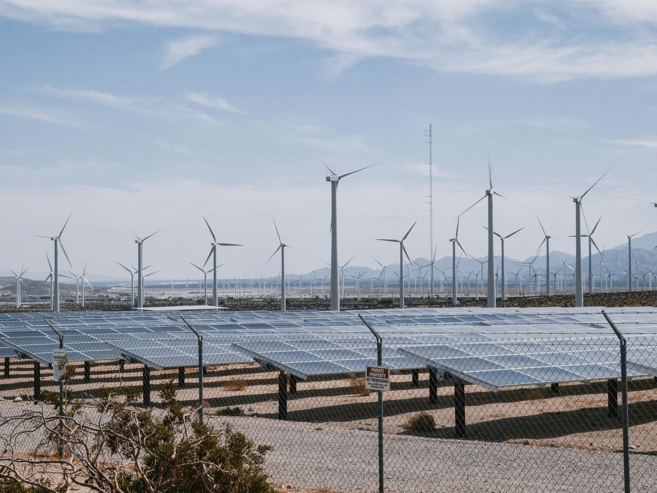
⚡ Renewable Energy Optimization and Grid Resilience
The transition to renewable energy depends on accurate predictions of solar radiation, wind patterns, and hydropower potential. AI models processing satellite data forecast renewable energy generation with increasing precision, helping grid operators balance supply and demand while maximizing clean energy use.
Satellite observations of cloud cover, atmospheric conditions, and surface temperatures feed into AI systems that predict solar energy production hours or days in advance. Similarly, wind energy forecasting benefits from machine learning models that analyze satellite data on atmospheric conditions across vast regions.
Climate-adapted energy infrastructure planning uses AI analysis of satellite data to identify optimal locations for renewable energy installations, assess climate risks to existing facilities, and design resilient transmission systems capable of withstanding extreme weather events.
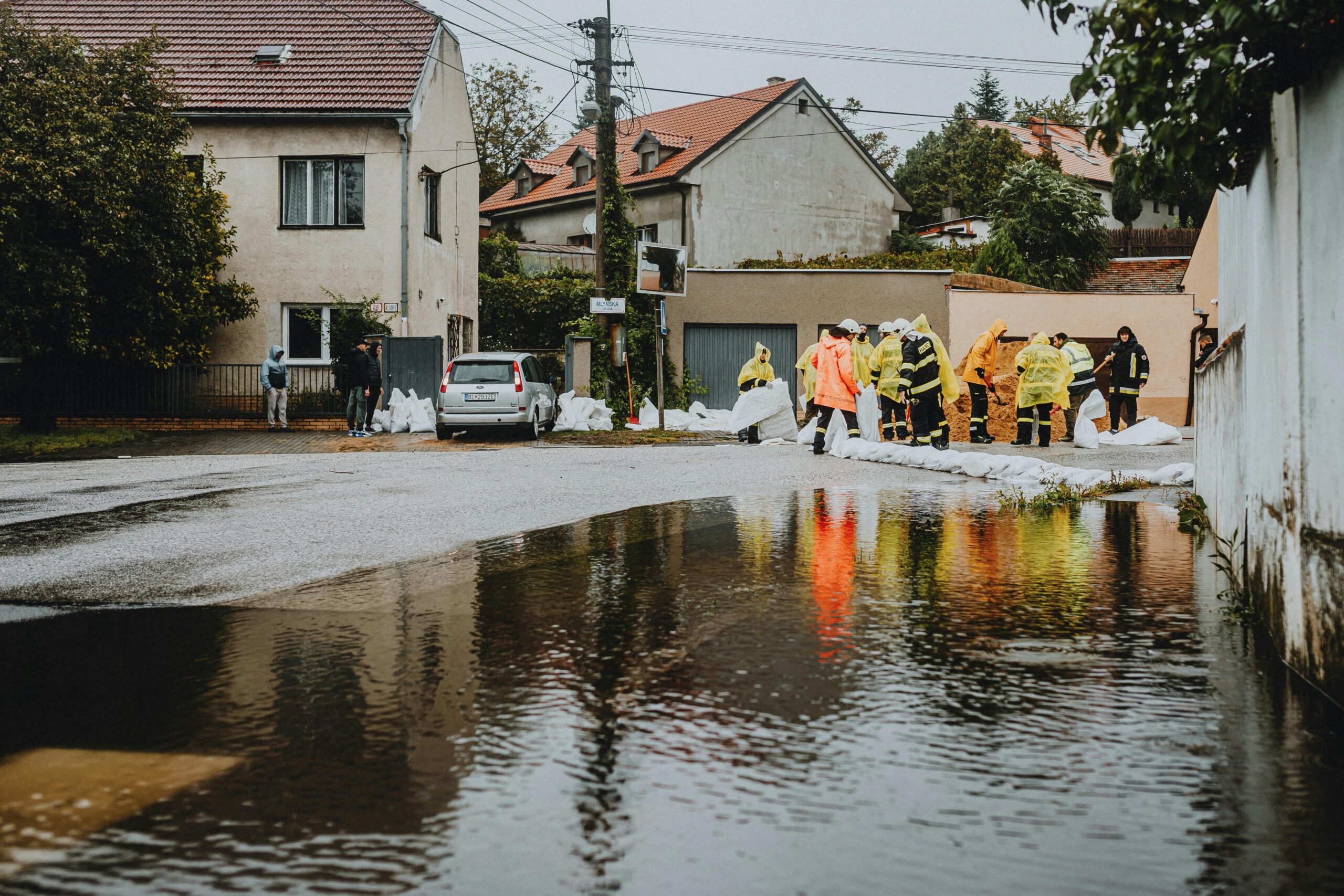
🚨 Emergency Response and Disaster Management Revolution
When disasters strike, rapid assessment of damage and needs determines how effectively emergency services can respond. AI algorithms process satellite imagery captured immediately after hurricanes, earthquakes, floods, or wildfires to map affected areas, identify damaged infrastructure, and prioritize rescue operations.
Damage assessment that once took days or weeks now occurs in hours. Machine learning models compare pre-disaster and post-disaster satellite images to quantify destruction, identify blocked roads, locate displaced populations, and guide humanitarian assistance to those most in need.
Predictive models help emergency managers anticipate cascading effects from disasters, such as disease outbreaks following floods or food insecurity after droughts. This foresight enables proactive deployment of medical resources, food aid, and other support services before secondary crises develop.
🔬 Advancing Climate Science Through AI-Powered Research
Climate scientists use AI to extract insights from satellite datasets too vast for traditional analysis methods. Machine learning accelerates the identification of climate trends, improves understanding of feedback mechanisms, and refines projections of future climate scenarios.
AI models help researchers quantify carbon emissions from specific sources, track methane leaks from oil and gas infrastructure, monitor forest carbon stocks, and assess the effectiveness of climate mitigation projects. This detailed accounting supports evidence-based climate policy and corporate sustainability initiatives.
Climate model development benefits from machine learning techniques that identify relationships between variables, improve parameterizations of complex processes, and reduce computational requirements for running sophisticated simulations. These advances enable more detailed and accurate climate projections.
🤝 Democratizing Climate Intelligence for Global Impact
One of the most promising aspects of AI-powered satellite climate monitoring is its potential to democratize access to environmental intelligence. Cloud-based platforms make sophisticated analysis tools available to researchers, policymakers, and communities worldwide, regardless of technical expertise or financial resources.
Developing nations often lack extensive ground-based monitoring networks but face severe climate risks. Satellite data processed by AI provides these regions with critical climate intelligence for adaptation planning, disaster preparedness, and sustainable development initiatives.
Open-source AI tools and freely available satellite data from government programs enable grassroots organizations, local governments, and community groups to monitor environmental conditions, advocate for climate action, and implement local resilience measures informed by the same technology used by major research institutions.
🎯 Overcoming Challenges and Ethical Considerations
Despite tremendous potential, integrating AI and satellite data for climate action faces several challenges. Data quality and availability vary across regions and time periods. Cloud cover limits optical satellite observations in some areas. AI models require careful validation to ensure predictions are accurate and reliable.
Computational resources needed for processing massive satellite datasets and training complex AI models create barriers for some organizations. However, cloud computing platforms and increasingly efficient algorithms are gradually reducing these barriers.
Ethical considerations include data privacy when satellite observations capture human activities, equitable access to climate intelligence technologies, and ensuring AI systems don’t perpetuate biases that could disadvantage vulnerable communities. Addressing these concerns requires ongoing dialogue among technologists, policymakers, and affected communities.
🌟 The Path Forward: Integration, Innovation, and Implementation
The future of climate action increasingly depends on seamlessly integrating AI-powered satellite intelligence into decision-making processes at all levels. Governments need standardized protocols for incorporating predictive models into policy development. Communities require accessible interfaces for understanding local climate risks. Businesses must integrate climate intelligence into strategic planning and risk management.
Continued innovation in both satellite technology and artificial intelligence promises even greater capabilities. Next-generation satellites will provide higher resolution data at greater frequencies. Advanced AI architectures will extract increasingly nuanced insights from this information. The convergence of these technologies with Internet of Things sensors, social media data, and traditional observations will create comprehensive climate intelligence systems.
Implementation remains the critical challenge. Technical capabilities must translate into practical actions that reduce emissions, enhance resilience, and protect vulnerable populations. This requires sustained investment in technology development, capacity building for using these tools effectively, and political will to act on the insights they provide.
💡 Empowering Action Through Knowledge and Technology
The revolution in climate action powered by AI and satellite data represents more than technological advancement—it embodies a fundamental shift in how humanity relates to environmental challenges. For the first time, we possess tools capable of matching the scale and complexity of climate change itself.
These technologies transform climate action from reactive crisis management to proactive risk reduction. They enable evidence-based decision-making, efficient resource allocation, and targeted interventions that maximize impact. Most importantly, they provide hope that humanity can navigate climate challenges successfully while building a more resilient and sustainable future.
Success requires collaboration across sectors, disciplines, and borders. Scientists must continue refining AI algorithms and satellite observation capabilities. Policymakers need to create frameworks that facilitate data sharing and technology deployment. Communities must be empowered to use these tools for local adaptation and resilience building. Together, these efforts can harness the full potential of AI and satellite technology to address the defining challenge of our time.
The climate crisis demands urgent action informed by the best available science and technology. AI-powered satellite monitoring provides the intelligence needed to predict risks, allocate resources effectively, and build resilience where it matters most. As these technologies mature and become more accessible, they offer genuine grounds for optimism that humanity can forge a sustainable path forward, protecting both people and planet for generations to come.