The convergence of biodiversity monitoring and land-use planning represents one of the most significant opportunities in modern environmental management. As our planet faces unprecedented ecological challenges, the integration of these two critical data streams is opening pathways to more informed, sustainable decision-making.
For decades, conservation efforts and land development have operated in relative isolation, creating fragmented approaches that often miss crucial connections. Today’s technological advances and data analytics capabilities are changing this paradigm, enabling stakeholders to see the bigger picture and make decisions that benefit both human development and natural ecosystems.
🌍 The Data Revolution in Environmental Management
The digital transformation sweeping across industries has finally reached environmental conservation and land management with full force. Satellite imagery, remote sensing technologies, and citizen science initiatives are generating unprecedented volumes of data about species distribution, habitat health, and land-use patterns. This wealth of information, however, only becomes truly powerful when different data types are brought together in meaningful ways.
Integrated biodiversity and land-use databases are now capturing everything from migratory patterns of endangered species to soil composition, urban expansion rates, and agricultural productivity metrics. The challenge lies not in collecting data, but in creating systems that can synthesize these diverse information sources into actionable insights.
Breaking Down Traditional Silos
Historically, environmental agencies tracked wildlife populations while urban planners focused on infrastructure development, and agricultural departments monitored crop yields independently. This compartmentalized approach meant that critical relationships between land use and biodiversity often went unnoticed until problems became severe.
Modern integrated platforms are dismantling these barriers by creating unified databases where multiple stakeholders can access and contribute information. When a city planner can instantly see how a proposed highway might intersect with critical wildlife corridors, or when farmers can understand how their irrigation practices affect downstream aquatic ecosystems, decision-making fundamentally improves.
Practical Applications Transforming Industries
The real-world applications of integrated biodiversity and land-use data extend across numerous sectors, each discovering unique benefits from this holistic approach to environmental information management.
Urban Planning with Ecological Intelligence
Cities worldwide are incorporating biodiversity considerations directly into their expansion plans. Using integrated data platforms, urban planners can identify green corridors that allow wildlife movement through metropolitan areas, preserve pollinator pathways essential for urban gardens, and protect wetlands that provide natural flood control.
Singapore’s “City in a Garden” initiative exemplifies this approach, using comprehensive biodiversity mapping alongside development plans to maintain ecological connectivity despite intense urbanization. The result is a metropolis where nature and infrastructure coexist in carefully designed harmony.
Agricultural Optimization and Conservation
Farmers and agricultural enterprises are discovering that biodiversity data enhances productivity rather than constraining it. Integrated platforms reveal which native plant species can serve as natural pest deterrents, where hedgerows can simultaneously provide wildlife habitat and protect crops from wind damage, and how maintaining riparian buffers improves both water quality and yields.
Precision agriculture technologies now incorporate biodiversity metrics, allowing farmers to optimize land use for both production and conservation outcomes. This approach recognizes that healthy ecosystems provide essential services—pollination, pest control, soil health—that directly support agricultural success.
Infrastructure Development with Minimal Impact
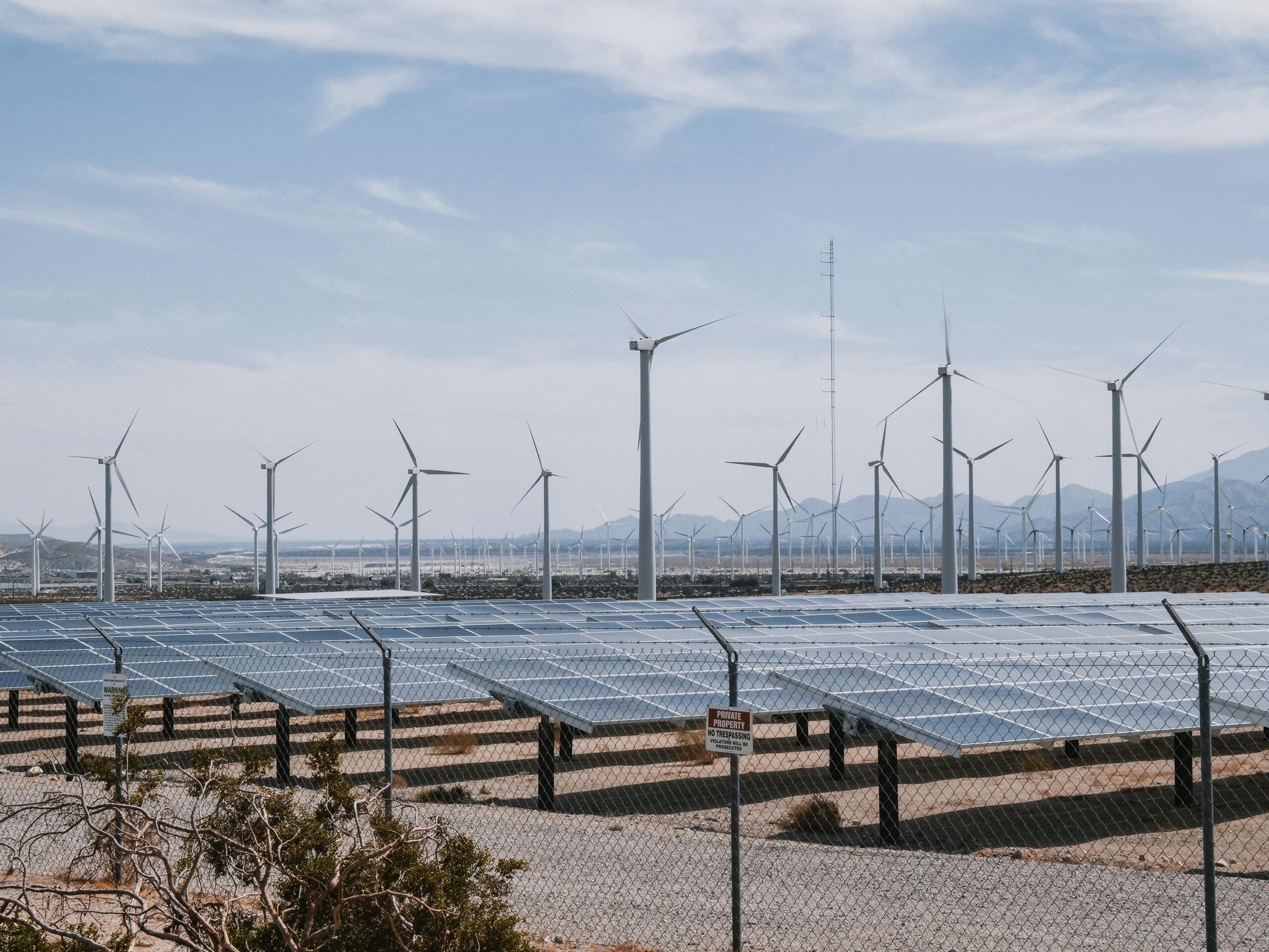
Energy companies, transportation authorities, and telecommunications providers face constant pressure to expand networks while minimizing environmental harm. Integrated biodiversity and land-use data enables these industries to identify development routes that avoid sensitive habitats, schedule construction activities around breeding seasons, and implement targeted mitigation measures where impacts are unavoidable.
Wind farm developers, for instance, now use detailed bird migration data combined with wind resource mapping to site turbines in locations that maximize energy generation while minimizing collision risks for avian species.
🔬 Technologies Powering the Integration
Several technological innovations have converged to make large-scale data integration feasible and practical for organizations of all sizes.
Geographic Information Systems (GIS) as the Foundation
Modern GIS platforms serve as the backbone for integrated environmental data systems, providing the spatial framework that allows different data types to be overlaid and analyzed together. These systems have evolved from specialized tools requiring expert knowledge to increasingly user-friendly platforms accessible to diverse stakeholders.
Cloud-based GIS solutions now enable real-time collaboration, where conservationists in the field can upload biodiversity observations that immediately become visible to land-use planners in government offices, creating dynamic, constantly updated environmental intelligence.
Remote Sensing and Earth Observation
Satellite technology delivers comprehensive land-use data at scales and frequencies impossible through ground-based surveys alone. Modern sensors can detect vegetation health, water stress, land-cover changes, and even individual large animals from space.
When combined with biodiversity records from ground observations, these remote sensing datasets reveal patterns invisible to either data source alone—such as how gradual habitat degradation precedes local species extinctions, or which landscape features facilitate species persistence in human-modified environments.
Artificial Intelligence and Machine Learning
The volume and complexity of integrated biodiversity and land-use datasets exceed human analytical capacity. Machine learning algorithms excel at identifying patterns, predicting outcomes, and flagging anomalies across these massive information streams.
AI systems can now predict where undiscovered species populations likely exist based on habitat characteristics, forecast how land-use changes will affect biodiversity years in advance, and automatically flag development proposals that pose significant ecological risks.
📊 Creating Meaningful Data Standards
For integration to work effectively, different organizations must adopt compatible data standards and sharing protocols. The development of these standards represents a crucial, ongoing challenge in the field.
Interoperability Frameworks
International initiatives like the Global Biodiversity Information Facility (GBIF) and the Land Portal Foundation are establishing common formats and protocols that allow seamless data exchange. These frameworks ensure that a species observation recorded by a researcher in Brazil can be automatically integrated with land-use data from government agencies and recognized by conservation planning tools worldwide.
Standardization doesn’t mean uniformity—successful frameworks maintain flexibility for local needs while ensuring core data elements remain compatible across systems.
Data Quality and Verification
With numerous contributors feeding information into integrated systems, maintaining data quality becomes paramount. Modern platforms incorporate multiple verification layers, from automated algorithms that flag improbable entries to expert review processes and cross-referencing with authoritative sources.
Citizen science contributions, while enormously valuable for coverage and scale, require particular attention to quality assurance. Successful systems combine community observations with professional validation to maximize both participation and reliability.
🌱 Success Stories Demonstrating Impact
Across continents, integrated biodiversity and land-use data initiatives are generating measurable conservation and development benefits.
The Amazon Basin Monitoring System
Brazil’s comprehensive Amazon monitoring program integrates deforestation alerts, indigenous territory boundaries, species distribution data, and agricultural expansion patterns into a unified early-warning system. This integration has enabled authorities to respond more rapidly to illegal clearing, identify sustainable development opportunities, and recognize areas requiring immediate protection.
The system’s effectiveness increased significantly when data integration allowed analysts to see not just where deforestation was occurring, but which species habitats were specifically threatened and which communities were affected.
European Green Infrastructure Strategy
The European Union’s green infrastructure initiative relies heavily on integrated biodiversity and land-use datasets to identify strategic conservation priorities across member states. By mapping ecological networks alongside development pressures, the program guides investments toward creating connected protected areas that maintain ecosystem functionality at continental scales.
This approach has shifted conservation from protecting isolated reserves to building resilient ecological networks that can adapt to climate change and coexist with human land uses.
African Wildlife Corridor Protection
Several African nations are using integrated data platforms to protect wildlife corridors essential for the migrations that sustain famous ecosystems. By combining GPS tracking data from collared animals with detailed land-use information, conservationists identify bottlenecks where development threatens connectivity and work with communities to maintain passageways.
This data-driven approach has proven more effective and cost-efficient than traditional methods, targeting interventions precisely where they deliver maximum conservation value.
💡 Overcoming Implementation Challenges
Despite its promise, integrating biodiversity and land-use data presents significant challenges that organizations must address for successful implementation.
Funding and Resource Constraints
Building comprehensive integrated data systems requires substantial initial investment and ongoing maintenance resources. Many conservation organizations and government agencies operate under tight budgets that make large-scale data integration difficult.
Successful initiatives often adopt phased implementation approaches, starting with priority regions or data types and expanding gradually. Public-private partnerships and international funding mechanisms increasingly support these efforts, recognizing that the long-term benefits justify upfront costs.
Technical Capacity Building
Effective use of integrated data systems requires specialized skills that remain scarce in many regions. Training programs that build capacity among conservation practitioners, government officials, and community stakeholders are essential complements to technology deployment.
Open-source platforms and intuitive user interfaces are democratizing access, allowing organizations with limited technical expertise to benefit from sophisticated analytical capabilities.
Political and Institutional Barriers
Data sharing across agencies and jurisdictions often encounters resistance rooted in institutional cultures, concerns about transparency, or competition for resources. Overcoming these barriers requires leadership commitment, clear governance frameworks, and demonstrated benefits that build trust among stakeholders.
Successful initiatives typically establish neutral governance structures that ensure all contributors maintain appropriate access to data while protecting sensitive information about endangered species or indigenous knowledge.
🚀 The Future of Integrated Environmental Intelligence
The field of integrated biodiversity and land-use data continues evolving rapidly, with emerging technologies and approaches promising even greater capabilities.
Real-Time Monitoring and Adaptive Management
Next-generation systems are moving toward true real-time monitoring, where biodiversity sensors, satellite feeds, and land-use tracking update continuously, enabling adaptive management responses to emerging situations. When a wildfire threatens critical habitat, integrated systems can immediately identify affected species, suggest evacuation corridors for wildlife, and coordinate emergency responses.
Predictive Modeling and Scenario Planning
Advanced modeling capabilities allow stakeholders to explore “what-if” scenarios before making irreversible decisions. Urban planners can test how different growth patterns would affect local biodiversity decades into the future, while conservation agencies can model where climate change will shift species distributions and prioritize land protection accordingly.
Blockchain for Data Integrity
Emerging applications of blockchain technology promise enhanced data integrity and traceability for integrated environmental databases. These systems could provide immutable records of biodiversity observations and land-use changes, increasing trust in data quality and supporting accountability mechanisms.
🤝 Building Collaborative Networks
The greatest potential of integrated biodiversity and land-use data lies not in the technology itself, but in the collaborative networks it enables. When researchers, policymakers, businesses, and communities share a common information foundation, they can engage in more productive dialogue about balancing conservation and development.
Multi-stakeholder platforms built around shared data are fostering innovative solutions that would have been impossible in more fragmented information environments. Indigenous communities are contributing traditional ecological knowledge that enriches scientific datasets, while corporations are discovering business opportunities in ecosystem restoration informed by comprehensive biodiversity data.
🌟 Pathways Forward for Every Stakeholder
Organizations and individuals across all sectors can contribute to and benefit from the integration of biodiversity and land-use data.
Government agencies should prioritize open data policies that make environmental information publicly accessible while establishing standards that ensure interoperability. Conservation organizations can focus on data collection in underrepresented regions and species groups, filling critical knowledge gaps. Businesses should integrate environmental data into planning processes, recognizing that sustainability and profitability increasingly converge.
Educational institutions have opportunities to train the next generation of environmental data scientists, while technology companies can develop user-friendly tools that democratize access to sophisticated analytical capabilities. Citizens can contribute observations through community science programs, expanding the reach and resolution of biodiversity monitoring.

Realizing the Vision of Harmonious Coexistence
The integration of biodiversity and land-use data represents more than a technical achievement—it embodies a fundamental shift in how humanity relates to the natural world. By making visible the connections between our land-use decisions and their ecological consequences, these systems create accountability and enable wiser choices.
We stand at a pivotal moment where the tools, data, and understanding necessary to balance human development with biodiversity conservation are finally converging. The path forward requires continued investment in data infrastructure, commitment to collaboration across traditional boundaries, and recognition that healthy ecosystems and thriving human communities are mutually reinforcing rather than competing goals.
As integrated data systems become more sophisticated and widespread, they promise to transform environmental management from reactive crisis response to proactive stewardship. The possibilities they unlock—sustainable cities, productive landscapes that support wildlife, infrastructure that enhances rather than degrades ecosystems—represent the practical pathways toward a future where nature and human development genuinely thrive together.
The technical foundations are established, the benefits are increasingly clear, and the global community is recognizing the urgency of action. Now the challenge lies in scaling these approaches, ensuring equitable access to data and insights, and maintaining commitment to the long-term vision even when facing short-term pressures. With integrated biodiversity and land-use data as a cornerstone, we can build decision-making systems worthy of the complex, interconnected world we inhabit.